I need to setup something to distribute maps, ideas, tips and other things better than this blog. Planning to set that up soon, but not sure when.
I need to setup something to distribute maps, ideas, tips and other things better than this blog. Planning to set that up soon, but not sure when.
 The nutrients you get from eating vegetables comes from soil! Credit: Mary Beth Adams
Healthy humans indeed need healthy soils!
View original post 197 more words
I purchased and used two examples of each of the Salsa Delgado 700C/29ers rims: the typical rim brake CX version still sold, the retired Disc and retired Disc Race. The Disc versions were sold off or retired years ago. The rim brake versions are still going strong, even with the cracks next to the eyelets.

Salsa Delgado CX rim showing cracks after 5+ years
Many people seem to trash the reputation of these rims on-line, but just like everything on-line, the crabby people are the most visible. All six of these rims have failed, however, I am satisfied with them. They all lasted a long time, did not cost much, and performed as expected.
First the Disc 29er ones. I bought them built with XT disc hubs for like $125 around 2006. The rims developed an annoying rattle. Salsa recalled them and I got brand new rims and Salsa covered the labor and new spokes to rebuild them. I then ran those rims for years until I gave them away to Mt. Rainer Bike Co-Op
The Disc Race 29ers were built up by a skillful builder with XTR disc hubs. They were great! Light and caused me no troubles until, my lame ass technique taco’ed the front in the 2009 SM100. It may have happened with any wheel, but probably not with a heavier & tougher rim. The rear then broke at the weld about a month later, regardless, I got three years out of those racey rims. Totally ok with me.
Lastly the two CX versions. They have been beat and beat on a series of CX and commuter bikes. The front one’s brake track is so worn that I need to retire it. The rear (pictured) developed the cracks between the eyelets. This is reported by many, but after 8 years and how it was used it is totally ok with me.
This is the MoCo Epic map showing all the courses. It does not show the location of the aid stations, start finish, etc. Those were not needed for this version for the folks assembling the documents. I am making other versions with the aid stations locations, direction arrows and a separate map for each course.
The new maps for the 2014 MoCo Epic are currently being proofed. They should be available from the organization shortly.
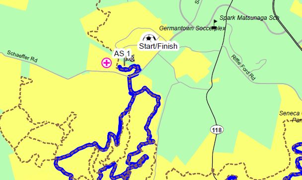
Just a taste of the MoCo Epic maps
Ride with GPS is offering map updates for Garmin units for $25. That is much cheaper than Garmin charges, however, the map data is using Open Street Maps (OSM) data which you can download to Garmin units for free. This website offers info on how to do download OSM data and put it on your GPS unit. At home, I have links to a very concise webpage with very easy to follow directions. I will update this posting with that info soon. Thew data on my Garmin Oregon 300 (from about 2005) works fine with it and can even follow the roads and trails for driving/riding directions.

Garmin Oregon
Shenandoah Mountain Touring is holding the 19th annual Shenandoah 100 Sunday August 31 on Labor Day weekend. There are no planned course changes for 2014 since the 2013 event. None. Not one. 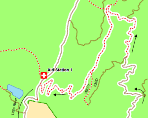 Links to the profile and maps:
I plan to work on the on-line version a bit more. I also will make a few changes to the print versions as well. A lot of new data is available that will make them look better.
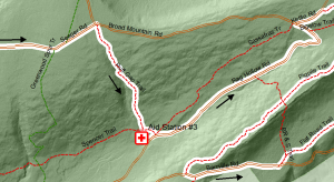 The Shenandoah Mountain Touring is holding the 17th annual Wilderness 101 this Sat July 26. There are no planned course changes for 2014 since the 2013 event. None. Not one. There were major changes last year around aid station #3 and #5. The maps showing those changes are:
I made a new series of six maps that cover the entire course. These maps are set up to print at either typical letter size or tabloid (17″ by 11″). There are multiple minor improvements plus I added an underlying elevation model based hill-shade to highlight the terrain:
The 2014 Stoopid 50 is Sunday June 15. The race is run by Shenandoah Mountain Touring LLC. The course is changing just a little. First there will be minor changes near the finish due to a much needed re-route of Chute Trail after Three Bridges. Second a proposal has been made to change the location of the aid stations to minimize impact on traffic. Lastly there may be changes in the Coopers Gap area to avoid trails susceptible to damage in wet conditions.
AND, now as of May 20th, Dutch Alvin Trail will be included in the race if it is dry. The maps have been updated to show that.
2014 Stoopid 50 Map for Dry Conditions
2014 Stoopid 50 Map for Wet Conditions